|
|
The
==Navigator== Containing
Directions for Navigating
The Monongahela, Allegheny, Ohio and Mississippi Rivers
9th Edition, 1817
Page 79:
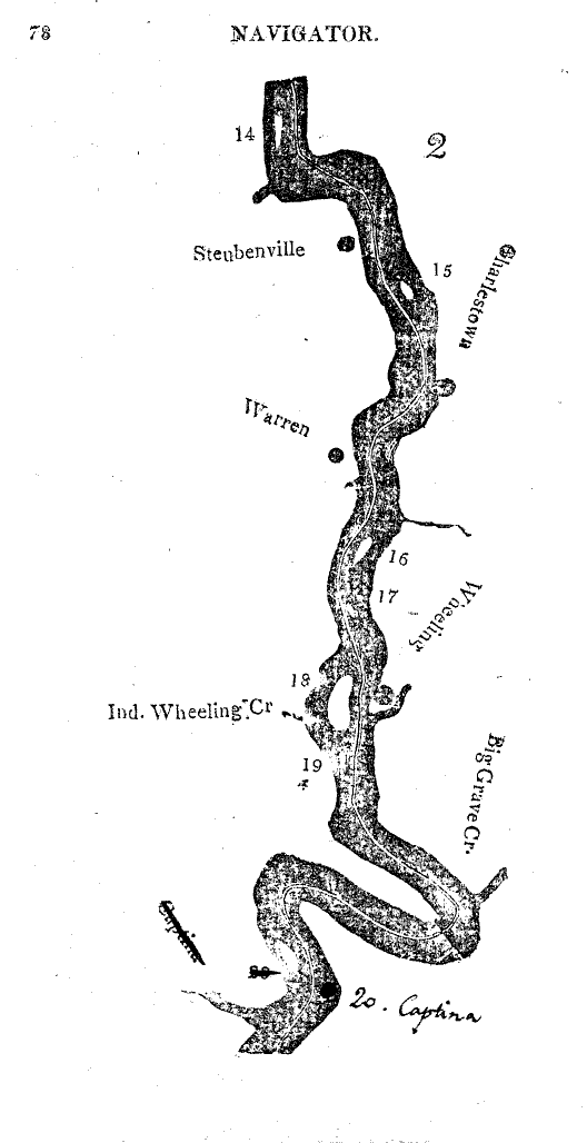
No. 18, Wheeling island, about a mile long, Channel left side. At the upper end of the island, keep pretty close to the left shore, until you see the town , then bear towards the island to avoid some logs near the left shore. After passing the town, keep near the middle of the river. Across the river,
Page 80:
On the right side of the island, there is a rope fixed from bank to bank to facilitate the passage of the ferry flats, but which prevents the descent of boats.
No. 18 is a fine large island, well farmed, and owned by col. Zanes, a very respectable old gentleman, and among the first adventurers to the county.
Indian Wheeling creek puts in on the right side opposite Wheeling island, just above whose mouth is a small village called Canton, containing a few scattered houses.
Wheeling, (town of)
Fronts the Ohio on a high gravely bank, opposite the middle of the island, and having immediately back of the town, Wheeling creek hill, which is steep and lofty, and so narrow at the top, that in some places there is scarcely room for a wagon to pass along, and is nearly a perpendicular precipice to the bottom of the creek. This singular formed backbone, as it were, between the Ohio and Wheeling creek, slopes off gradually into a fine bottom just below the town and above the mouth of the creek, but which is considerably lower than the ground on which Wheeling stands, and in some seasons has been known to be inundated by the floods. There are on this bottom an excellent public inn, a warehouse, a boat yard, and a rope walk, and some other buildings. Immediately above the mouth of the creek there used to stand a fort, serving as a frontier post during the wars with the Indians.
In consequence of the hill just mentioned, and which crowds the town close to the bank of the river, Wheeling has but one street, which is thickly built on for a quarter of a mile in length. The town has about 115 dwellings, 11 stores, two potteries of stone ware, a market-house, and it had in 1808-9, a printing office, a bookstore, and a library; the first two quit the town for want of patronage, the last is still upheld by the citizens. The mail stage from Philadelphia, Baltimore, &c. arrives here twice a week, by way of Pittsburgh, Washington and Charlestown; thence westward the mail is dispatched once a week on horses.
The town has a court-house and jail, it being the seat of justice for Ohio county, Virginia. It is 58 miles S. W, of Pittsburgh, and 110 W. by N of Cumberland. The hills about Wheeling contain a good mineral coal, which is used as fuel. The thoroughfare through Wheeling, of emigrants and travelers into the state of Ohio and down the river, is very great in the fall and spring seasons. Boats even descend from this place in all seasons of the year., and those going down the Ohio from Maryland and the lower parts of Virginia, if the water be too low at Brownsville, pass on to Wheeling for embarkation, where boats and other necessary provisions can be had at a short notice.
St. Clairsville, a thriving town, and seat of justice for Belmont county, Ohio, is handsomely seated on high hill ground, in the midst of a fine rich settlement eleven miles west from Wheeling, on the direct road to Chilicothe, Limestone, &c.
Digital version of the Navigator
|

